Exploring Nature on the Trails at Cossatot River State Park
By: Shelley Flanary“The book of nature has no beginning as it has no end.” (Jim Corbett)
I am excited to tell you about the four trails we have and how our longest trail (“River Corridor”) is now completed for you to “experience the seasonal natural beauty along this wild and scenic river.”

Starting with our shortest trail, “The Waterleaf Interpretive Trail.” This trail begins at the Visitor Center and includes a section of barrier-free trail along the ridge top. This ½ mile trail goes down the North Slope to the Highway 278 river access. Please be careful and enjoy Arkansas’s natural world. The trail is marked with yellow medallions with a backpacker in the middle to help guide you along. This trail is rated easy to moderate (moderate meaning a hill to climb either way back to the top of the ridge).

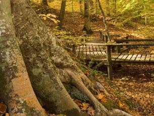
Our next shortest trail is, “Brushy Creek Interpretive Trail.” This trail starts on the west side of the river and provides barrier-free access to a pedestrian walkway over the river. The trail continues to the picnic area on the east side of this recreation area. This ¾ mile trail meanders through mixed foliage – pine and hardwood, and offers a scenic view overlooking the Cossatot River/Brushy Creek union. The numbered trees in the Trail Guide brochure corresponds with numeric labels placed near matching species along the trail. The Trail head is located 9 miles east of Vandervoort on the east side of Brushy Creek Recreation Area. It will end after you descend a flight of stairs into the parking lot. This trail is also marked with yellow medallions with a backpacker in the middle to help guide you along. This trail is rated easy to moderate (moderate meaning stairs to climb and a few small hills to get to the top of the ridge). Please be careful and enjoy Arkansas’s natural world.

Starting with our longer trails, the “Harris Creek Trail,” begins just off of Highway 278 near the Baker Creek Bridge and meanders through 3.5 miles of mature forest between Harris Creek and the river. The trail is marked with a blue medallion with a backpacker in the middle to show you the way.
The trail is scenic, and sections of the trail are rugged and steep.
Wear appropriate shoes and clothing and carry water. This trail is rated easy (short section of the trail), then moderate to difficult (moderate meaning several inclines and then it changes into steep switch backs. After you have made it to the top of the switch backs you will be walking on an old log road back to the parking area/trail head area.) Please be careful and enjoy Arkansas’s natural world.
Finally, our last trail is the “River Corridor Trail.” The River Corridor trail has been reconstructed over the last two years and is now a first class hiking facility. This trail is 14 miles long with several access points along the way. The trail is divided into three segments the first section starting at the park’s Brushy Creek Recreational Area on Arkansas Highway 246; approximately nine miles east of Vandervoort. It ends at Ed Banks, which is a five mile hike. The second section is from Ed Banks to the Falls, and it is a 2 mile hike. The third and final section is the longest part. It is a 7 mile hike from the Falls to the U.S. Highway 278 Access Area, below the Visitor Center.

This entire trail is blazed in blue and is rated strenuous. Hikers have the option of walking the entire trail or choosing a particular segment. The trail is excellent for a two-to-three-day backpacking adventure; however, hikers are asked to camp at the park’s designated camping facilities located at the Cossatot Falls, Sandbar Area, and the Ed Banks Area, or the undeveloped U.S. Highway 278 Access. Also you need to stop in at the Visitor Center (located on the U.S. Highway 278 Area) to fill out a Yellow Slip (Trail Register) to hang on your mirror.
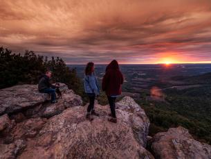
According to Park Superintendent Stan Speight, “hikers have the opportunity to choose a trail length that best fits the amount of time they have to go hiking.”
He noted that the shortest segment is the middle section which stretches two miles in length. “Trail enthusiasts can enjoy a morning or afternoon hike, and all-day hike, or a weekend of adventure experiencing the entire 14 miles,” said Speight. “And since the trail follows the Cossatot River Corridor, each segment offers the opportunity to experience the seasonal natural beauty along this wild and scenic river.”
With all four of our trails, Please take only pictures and leave only footprints. We support the LNT (Leave No Trace) Principles, which are: Plan Ahead and Prepare, Travel and Camp on Durable Surfaces, Dispose of Waste Properly, Leave what you Find, Respect Wildlife, and Be Considerate of other Visitors.
If you have any questions or comments contact a park ranger or call (870) 385-2201. We hope you enjoy your stay at the Cossatot River State Park-Natural Area. From start to finish there are 20 –miles of different diverse hiking trails.
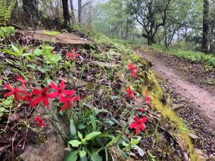
Trails are a great way to engage in nature. There are amazing things to see if you look close enough.
Start with experiencing aspects of nature that you can directly relate to with your physical, sensory, or emotional senses. You can also join or make reservations to have a personal Interpreter Guide as you hike along a trail.Your connections with nature will continue to go deeper and deeper as you ask questions and follow your sense of wonder. This connection is what brings about a sense of meaning in our lives—it deepens in each one of us a sense that we have a special place in this precious world.