Arkansas has hundreds of miles of the Trail of Tears, and of the nine states traversed by the trail, is the only state that witnessed the removal of all five of the Southeastern tribes as they moved west. Arkansas State Parks has five parks that lie along these removal routes. These parks have been certified as National Park Service Trail of Tears National Historic Trail Sites: Lake Dardanelle, Mount Nebo, Petit Jean, Pinnacle Mountain, and Village Creek state parks. This article will stimulate you to discover a brief history of the Trail of Tears and how it relates to Arkansas State Parks.
Arkansas State Parks has the unique opportunity to share the often-overlooked stories of all five of the Southeastern tribes that were removed.
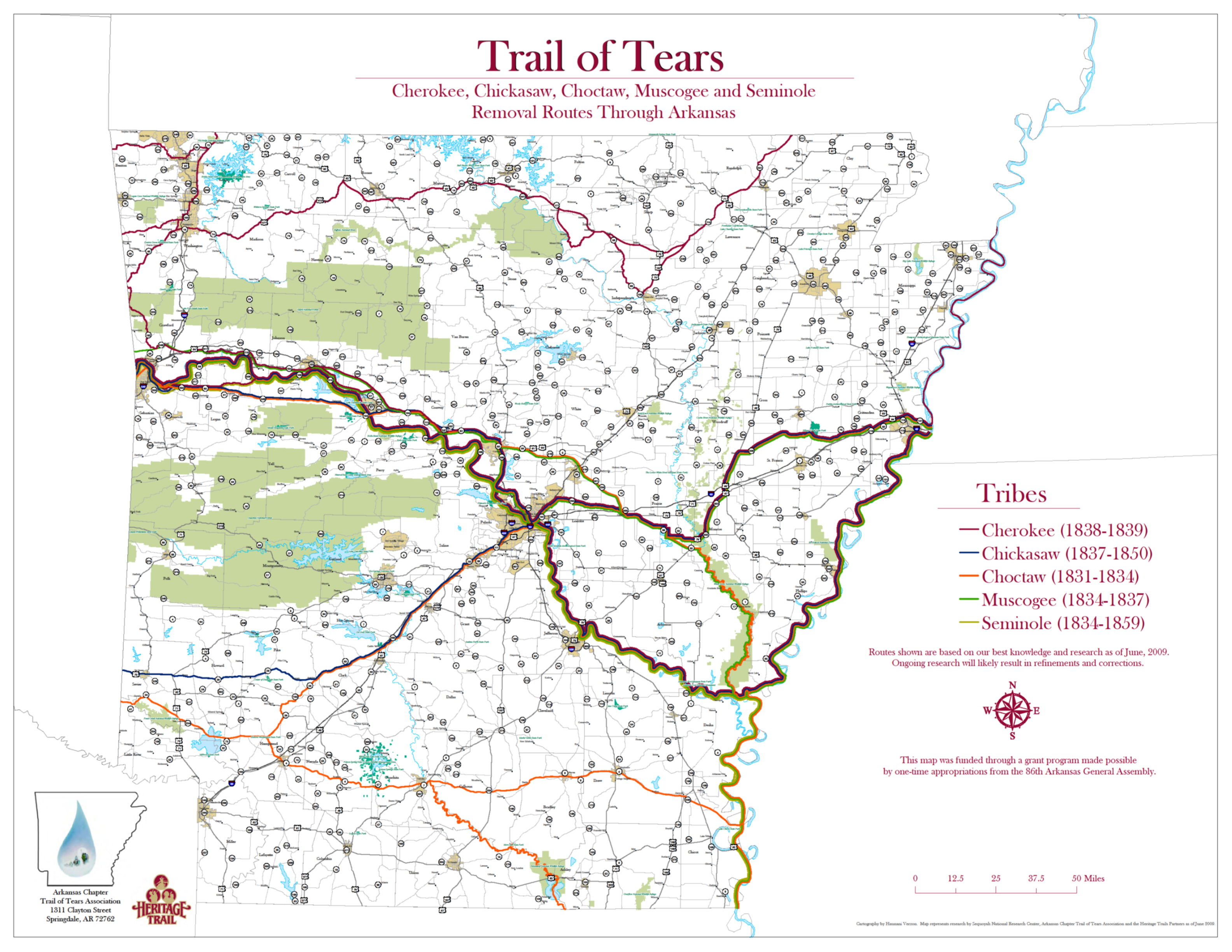 Map of the removal routes used by the five Southeastern tribes that removed to present day Oklahoma. Courtesy of Arkansas Chapter of the Trail of Tears Association.
Background
The era of the Trail of Tears is an unsettling and often forgotten part of U.S. history. The Trail of Tears refers to the forced removal of Cherokees from their homelands in the East to what is today, Oklahoma. This removal came about after numerous broken and forgotten treaties with the United States. The U.S. Government passed the federal Indian Removal Act of 1830. The government began rounding up Cherokees in their Eastern homelands in 1836. After the Cherokees were rounded up, they were divided into travel groups, called detachments. Each detachment had a “conductor” or leader. The roughly 1,000-mile journey of the Cherokee Trail of Tears was designated as a National Park Service National Historic Trail in 1987. This trail commemorates the removal of Cherokee from their homelands, the paths of their journey westward, and the rebuilding of the Cherokee Nation. Although the National Park Service trail designation is only for Cherokee removal there were five separate tribes (Cherokee, Chickasaw, Choctaw, Creek, and Seminole) removed from the Southeast that used many of the same removal routes.
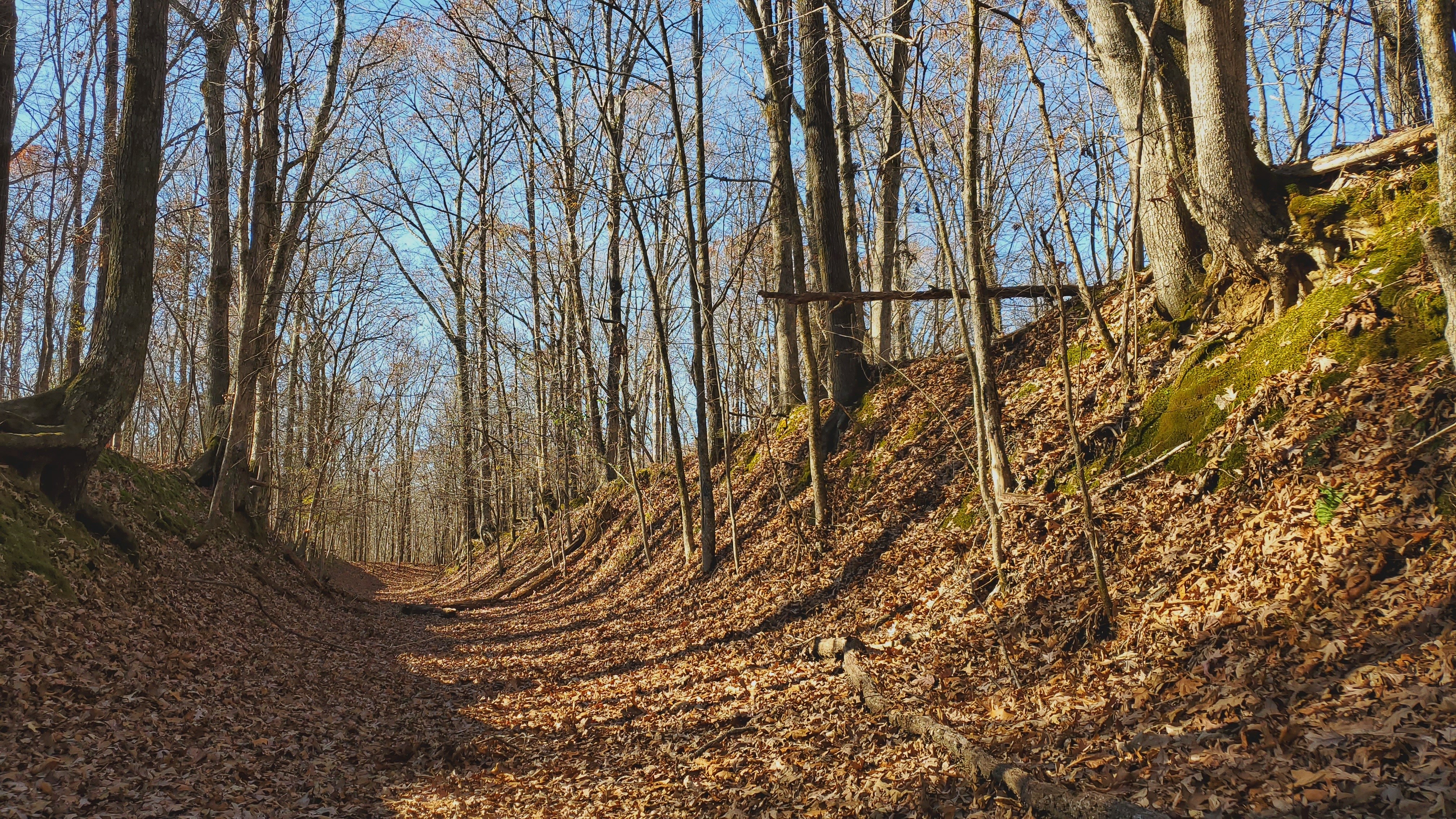 The remnant of the sunken roadway used during removal at Village Creek State Park. Photo Courtesy of Village Creek State Park.
Village Creek State Park and the Trail of Tears
Village Creek State Park located in Wynne, Arkansas, has the most intact segment of trail. The trail was used not only by the Cherokee in the Bell detachment (named for the conductor of the detachment, John Bell, the first to take this specific path west), but also Choctaws, Creeks, and Chickasaws during their removals. The Old Military Road Trail was originally part of the Memphis to Little Rock road. This trail offers a dramatic sunken remnant of the removal trail. Village Creek also encompasses parts of the landholdings of William Strong. He ran a store that was the second ration depot for supplying removal parties during the 1830s and was a stopping place for most travelers.
Choctaw Connection to Village Creek
As the first Southeastern tribe to relocate to Indian Territory, the Choctaws encountered difficulties and hardships as they proceeded west. The first removal groups in 1831 took a southern route from Arkansas Post to Little Rock. The following year they took different routes, including the route from Memphis to Little Rock. The first Choctaws to travel through the Village Creek site reached Memphis in October 1832. As with most groups that reached Memphis, the group split up. Many feared the steamboats because they associated them with cholera. Few boarded the boats. Those remaining chose the overland route using the Memphis to Little Rock road. They planned to reunite with the others at the Rock Roe (present-day Clarendon, Arkansas) landing on the White River. Taking the overland route involved crossing the difficult-to-navigate swamps. Some didn’t make it through the swamps, while others had to be rescued. The last removal party of Choctaws to pass through the Village Creek site crossed the Mississippi on November 2, 1833.
Creek Connection to Village Creek
While a large number of Creeks traveled through Arkansas on steamboats between 1834 and 1837, more Creeks than members of any other tribe went overland through Arkansas. Most traveled the Military Road and the Cantonment Gibson Road beginning in February 1835 and ending in November 1836. The Creeks traveled with numerous horses, requiring overland travel. George W. Morris recounted meeting some of the Creeks in 1836 “... They had nearly as many ponies as people…”
Chickasaw Connection to Village Creek
Chickasaw removal from Mississippi and Alabama resulted from the Treaty of Pontotoc in 1832 and a Supplemental Treaty in 1834. Chickasaw's removal began in the summer of 1837 after negotiations between the tribe and the U.S. Government concluded. The negotiations established terms that granted them some control over their removal, unlike the other tribes. The Chickasaws enjoyed some freedom in choosing which routes to take. The last major removal party of Chickasaws to go through the Village Creek site began their journey west in the fall of 1838, reaching Strong’s land in November. Although the Chickasaw were able to “control” their removal they couldn't control the elements. Some Chickasaw groups traveled with no issues. Other groups, however, encountered poor road conditions, mud, and the swamps were a formidable obstacle for the Chickasaws, especially with the large groups of their horses.
Cherokee Connection to Village Creek
Although many Cherokees had voluntarily removed to the West prior to 1835, the vast majority were subjected to forced removal beginning in 1838. This forced removal came after the Treaty of New Echota was signed in 1835 by a small group of Cherokees. Only one large contingent of Cherokees went through the Village Creek site. The Bell detachment arrived near Memphis on November 25, 1838. After crossing the Mississippi River and following the road through the swamps, they ferried across the St. Francis River on November 28 and 29 and spent several days at Strong’s land. From there they went through what is now Village Creek State Park on their way west.
Pinnacle Mountain, Petit Jean, and Mount Nebo State Parks
Pinnacle Mountain, Petit Jean, and Mount Nebo state parks are also certified Trail of Tears National Historic Trail Sites. Each of these mountains witnessed the hardships faced by the removal parties of the Cherokees, as well as, Choctaws, Creeks, Seminoles, and Chickasaws.
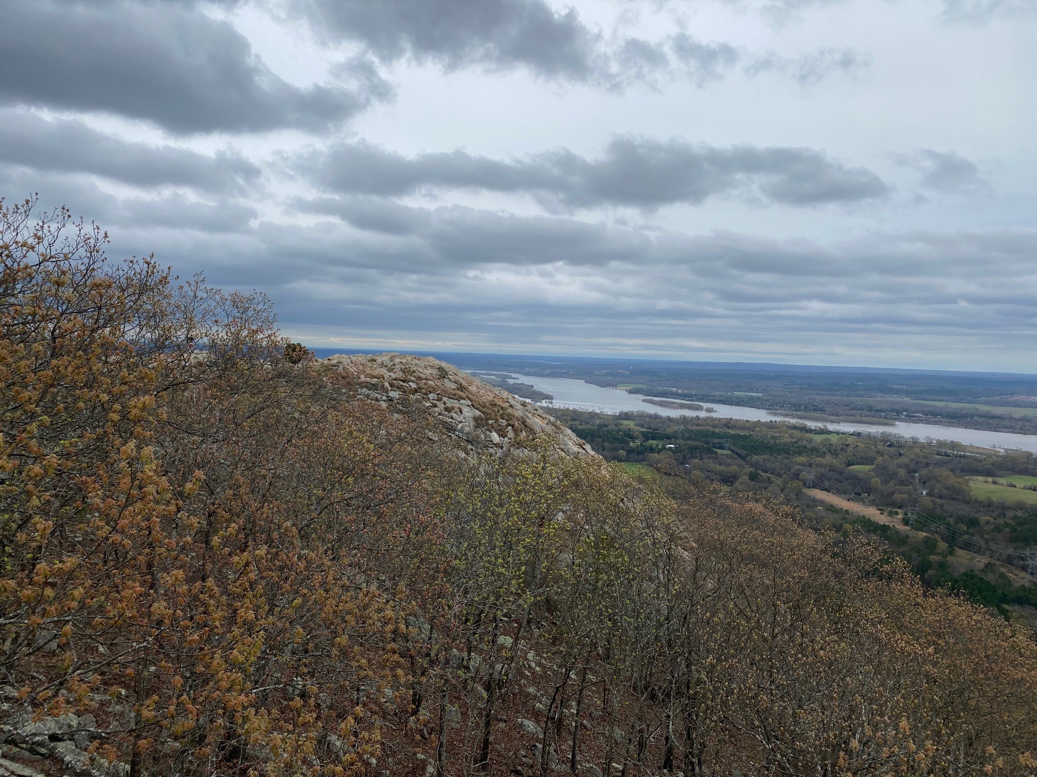 The view of the Arkansas River from Pinnacle Mountain State Park. Photo Courtesy of Pinnacle Mountain State Park.
You can catch breathtaking views of the Arkansas River from the summit and also from the East Quarry Trail at Pinnacle Mountain State Park, located in Little Rock, Arkansas.
 Sun peeking through the clouds shines down on the river as viewed from Petit Jean State Park. Photo Courtesy of Petit Jean State Park
In the 1830s, Cherokee Indians along with members from the other Southeastern tribes of the United States passed by Petit Jean Mountain during their forced migration to present-day Oklahoma. Petit Jean State Park is located in Morrilton, Arkansas. You can view a portion of this historic route from the overlook at Stout’s Point.
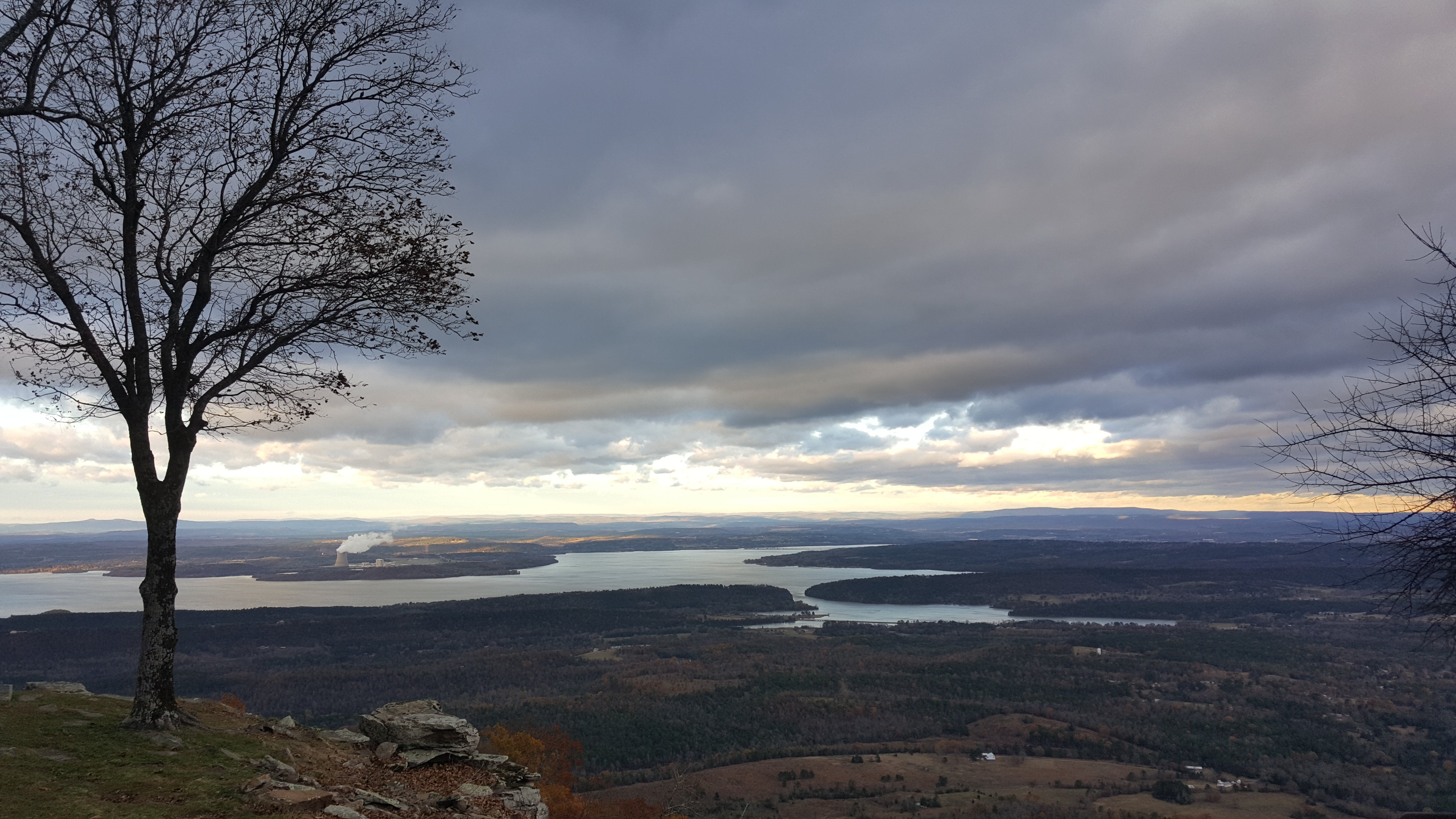 A view of the landscape from the top of Mount Nebo, with the Arkansas River in the distance. Photo Courtesy of Arkansas Department of Parks, Heritage, and Tourism.
Mount Nebo, overlooking the Arkansas River from the south, witnessed the removal of all five of the tribes that were removed along the water route of the Trail of Tears. Mount Nebo State Park in Dardanelle, Arkansas, offers panoramic views of the Arkansas River from the Rim Trail.
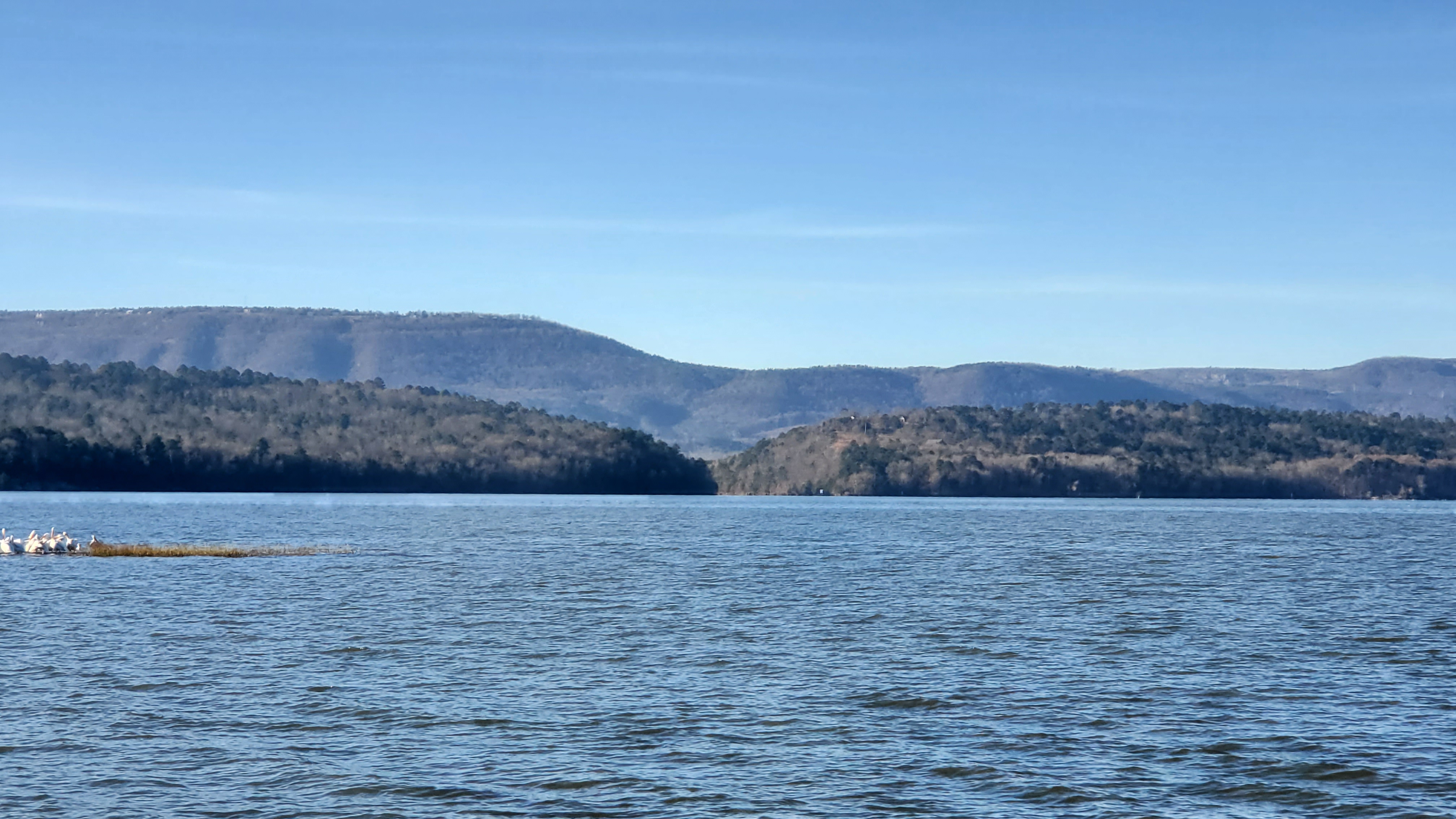 The view of the Arkansas River from the shore of Lake Dardanelle from behind the Lake Dardanelle State Park Visitor Center. Photo Courtesy of Lake Dardanelle State Park.
Lake Dardanelle State Park and the Trail of Tears
Lake Dardanelle State Park straddles the Arkansas River. The main body of the park is in Russellville, and a smaller section is located south of the river in Dardanelle. The residents of the area during this time period would have witnessed the river traffic related to water removal as well as some of the groups that traveled by land. The Lake Dardanelle State Park Visitor Center, located on the Russellville side of the park, offers spectacular views of the river along with exhibits that tell more of the removal story.
During the time of removal, Dardanelle was more of a village than a town and was a popular stopping point between Little Rock and Fort Smith. More important was Norristown, just across the river, which had a ferry crossing. The Norristown ferry played a vital role in this process. Removal parties choosing a more southerly route to “Indian Territory” crossed the river from Norristown to Dardanelle. Many continued on the north side of the river, taking the road to Dwight Mission, or the road that became Hickeytown Road. Between late 1831 and 1859, groups of Cherokees, Choctaws, Muscogees (Creeks), Seminoles, and Chickasaws passed through or by Norristown.
Choctaw Connection to Lake Dardanelle State Park
In the 1830 Treaty of Dancing Rabbit Creek, the Choctaws gave up their lands in Mississippi and agreed to move to Indian Territory. The Choctaws were the first tribe to remove, so they did not have established roads to use the entire way, nor could they draw a plan from other groups' experiences. Most of the Choctaws took a southerly route to the Choctaw Agency at Scullyville, crossing the river to travel south on the Military Road. They began passing through the area of Lake Dardanelle State Park in December 1831. Their last removal party made its way through Dardanelle in December 1833.
Creek Connection to Lake Dardanelle State Park
The 1832 Treaty of Washington was not specifically a removal treaty. It is, however, the treaty the government used to remove the Creeks from their homelands in Alabama, Georgia, Florida, and South Carolina. Most of the Creeks that traveled overland used the Cantonment Gibson to Little Rock Road on the north side of the river. There were a large number of Creeks that used the Arkansas River. River travel could prove dangerous during these times as it was unpredictable and riddled with debris. One Creek removal group aboard the steamboat Alpha hit a snag (dead tree underwater) near Lewisburg that disabled one of their keels. After getting back underway, the Alpha made it to Fort. Smith and hit low water. The group had to walk for the remainder of the trip to Ft. Gibson. The Creeks passed through Dardanelle beginning in January 1836 and continued to June 1837.
Seminole Connection to Lake Dardanelle State Park
The diversity of the Seminoles complicated their removal. A group of seven Seminoles claiming to represent the whole signed the Treaty of Payne’s Landing in May 1832 (to move from Seminole land to Creek lands). In May 1832 the Treaty of Fort Gibson was signed stating all Seminoles would remove to lands west of the Mississippi River. Because of the refusal of all the Seminoles to remove, they had the longest removal. They resisted removal and waged war to keep their homelands. Their removal groups were made up of “prisoners of war” or people who surrendered. The first removal began in 1836 but didn’t complete until 1859. Seminoles were almost exclusively removed through Arkansas on steamboats. Seminoles were put on boats, either steamboats or sailing ships, that took them from Florida to New Orleans and then up the Mississippi to the Arkansas River.
The first group of Seminoles to pass Dardanelle was on May 5, 1836. A number of steamboat parties and one overland party went through Dardanelle in 1838. The overland groups only traveled overland due to low water conditions. Two groups passed Dardanelle in 1839, three more in 1841, and there was one river and one land party that passed in 1842. No other Seminole removal parties passed Dardanelle until the 1850s.
Chickasaw Connection to Lake Dardanelle State Park
Many Chickasaws traveled the Southwest Trail from Little Rock on, many traveled by steamboat up the Arkansas River to Fort Coffee, while a few traveled the Military Road. The first Chickasaw removal passed Dardanelle in late July 1837 on the river. The first land crossing using the Norristown ferry was in August 1837. The third Chickasaw removal group that crossed the river from Norristown was so large with people and horses that it took them a week to get everyone across the river. Charles “Boggy” Johnson was with the group and wrote of their crossing. He also noted that the day after leaving Dardanelle the group had a smallpox outbreak. There were several more Chickasaw removal groups that passed through the area until the final group made its way through the area on June 8, 1838. The Chickasaw groups that traveled via the Arkansas River had favorable water conditions and were able to make the trip from Memphis to Fort Coffee in as little as eight days.
Cherokee Connection to Lake Dardanelle State Park
There were 17 Cherokee detachments total. The Water Route and the Bell Route came through the area that is now Lake Dardanelle State Park. The first three detachments were sent to “Indian Territory” via the water route in 1838, for which Lake Dardanelle State Park is a certified National Trail of Tears Site. Native Americans made decisions here that changed their lives. If they continued on water, they had to board keel boats because the larger steamboats could not make it any further upriver. If they decided to continue the journey on land, they had to walk the rest of the way to present-day Oklahoma.
The first group of Cherokees to ascend the Arkansas River traveled from Ross’s Landing on June 6, 1838, led by Lt. Edward Deas. They stopped at Little Rock and transferred to a lighter draft boat, the Little Rock, hoping to make it further up the river. They made it past Dardanelle only to reach McLean’s Bottoms, between Dardanelle and Fort Smith, before having to trek overland due to low water conditions. They arrived at Fort Coffee on June 23, 1838.
Capt. R.H.K. Whiteley led the second water route detachment leaving Ross’s Landing on June 12, 1838, to arrive at Little Rock by steamboat on July 4, 1838. The group was sick with measles, among other things, and camped above town for eight days. On July 14, they ran aground on Benton’s Bar near Lewisburg and camped out while waiting for Whiteley to obtain wagons. They finally started overland on July 20. On July 23, Whiteley wrote, “Started at sunrise, encamped at 12 n. at Illinois bayou to give the party time to beat corn and wash. Much sickness & a number of deaths daily.” On July 24, they camped at Sulphur Spring, “The party suffering much from sickness. Three to five deaths daily.” On July 25, they reached Piney Creek. The next day, they reached the “Little Spadry,” where they bought fresh beef from Josiah Cravens at Clarksville. This detachment arrived in “Indian Territory” on August 5, 1838.
Capt. G. S. Drane led the third detachment taking the water route, leaving Ross’s Landing on June 17, 1838, and arriving by steamboat at Little Rock on July 25, 1838, waiting several days due to low water. They boarded the Itasca but ran aground near Lewisburg on August 13. After camping out and waiting for wagons, they left Lewisburg on August 18. They arrived at their disbandment location at Mrs. Webber’s on September 7, 1838. Those first three detachments faced such misery; Chief John Ross requested permission to supervise their own removal. This was granted for the remaining detachments. The final Cherokee detachment passed Dardanelle in February 1839.
Certified Trail of Tears National Historic Trail Sites
It is important to remember that these five State Parks are certified Trail of Tears National Historic Trail Sites because of each site's connection to Cherokee removal. The story doesn’t end there because other tribes used the same removal routes. Arkansas State Parks has the unique opportunity to share the often-overlooked removal stories, of all five of the Southeastern tribes that were removed. Visit these parks to learn more about the Trail of Tears. You can get your Arkansas State Park passport stamped and each of these parks is a National Park Service National Historic Trail Site, you can also get a stamp for your National Park Passport for the Trail of Tears.
Resources:
Journey of Survival: Indian Removal Through Arkansas
Arkansas Trail of Tears Association

Sasha Bowles
Sasha Bowles is a Park Interpreter II at Lake Dardanelle State Park. She and her family take every opportunity to enjoy the beauty of Arkansas. She is enthusiastic about sharing her love of nature and area history with park visitors and the community.